


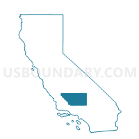
Voting District 10035, Kern County, California
About
Outline

Summary
| Unique Area Identifier | 531383 |
| Name | Voting District 10035 |
| County | Kern County |
| State | California |
| Area (square miles) | 38.15 |
| Land Area (square miles) | 38.15 |
| Water Area (square miles) | 0.00 |
| % of Land Area | 100.00 |
| % of Water Area | 0.00 |
| Latitude of the Internal Point | 35.61711400 |
| Longtitude of the Internal Point | -119.11905630 |
Maps


Graphs
Select a template below for downloading or customizing gragh for Voting District 10035, Kern County, California


Neighbors
Neighoring Voting District (by Name) Neighboring Voting District on the Map
- Voting District 10040, Kern County, CA
- Voting District 10080, Kern County, CA
- Voting District 10085, Kern County, CA
- Voting District 10235, Kern County, CA
- Voting District 10240, Kern County, CA
- Voting District 10241, Kern County, CA
- Voting District 10245, Kern County, CA
- Voting District 10250, Kern County, CA
- Voting District 10255, Kern County, CA
- Voting District 10405, Kern County, CA
- Voting District 10820, Kern County, CA
- Voting District 10830, Kern County, CA
- Voting District 10840, Kern County, CA
- Voting District 10910, Kern County, CA
Top 10 Neighboring County Subdivision (by Population) Neighboring County Subdivision on the Map
- Bakersfield CCD, Kern County, CA (393,778)
- Delano-McFarland CCD, Kern County, CA (68,758)
- Shafter CCD, Kern County, CA (21,642)
- Lake Isabella CCD, Kern County, CA (16,234)
Top 10 Neighboring Elementary School District (by Population) Neighboring Elementary School District on the Map
- Delano Union Elementary School District, CA (54,938)
- Richland-Lerdo Union Elementary School District, CA (19,085)
- Beardsley Elementary School District, CA (17,072)
Top 10 Neighboring Secondary School District (by Population) Neighboring Secondary School District on the Map
Top 10 Neighboring Unified School District (by Population) Neighboring Unified School District on the Map
Top 10 Neighboring State Legislative District Lower Chamber (by Population) Neighboring State Legislative District Lower Chamber on the Map
Top 10 Neighboring State Legislative District Upper Chamber (by Population) Neighboring State Legislative District Upper Chamber on the Map
Top 10 Neighboring 111th Congressional District (by Population) Neighboring 111th Congressional District on the Map
Top 10 Neighboring Census Tract (by Population) Neighboring Census Tract on the Map
- Census Tract 46.04, Kern County, CA (15,845)
- Census Tract 52.01, Kern County, CA (5,397)
- Census Tract 51.03, Kern County, CA (2,564)
- Census Tract 39, Kern County, CA (2,250)